July 19, 2010
Friends of the Geographical Names of Alberta' -- what a novel idea. A Society whose purpose is to document the names of places in Alberta. This society initiated a program they call 'Name Your Place'. It's intent is to collect information and documentation about how places in Alberta got their names.
In the here and now (2010) this type of information is becoming increasingly harder to collect. I suspect that this could be the result of the folks that gave the names not keeping proper records. They probably didn't think that it was a big deal and I doubt that they ever held any stakeholder meetings to get public opinion. Names were simply given as post office locations.
In Cree 'athabasca' meant 'place where the reeds grow'. Back in 1874 the Hudson's Bay Company needed a trail north from Edmonton out to the place where the reeds grow (Athabasca Landing). With a little planning and hard work the Athabasca Landing Trail came into existence. Now some 136 years later that name is legend with countless stories associated with the trail that became Alberta's first dominion highway and Canada's first toll road.
Names of other places came about in the opposite way. They had to earn them. First the history (reputation) then the name. The Opal Natural Areas and grazing leases are part of just such a location.
The Opal area is like a big sponge. Any moisture that falls in this area is soaked up by the many sand dunes and the huge muskeg bog. The water is trapped, prevented from escaping downwards by an underlay of bentonite clay. Moisture collected in this 4500 hectare sponge has only three ways of escaping -- by evaporation or by way of two small creeks. When the water levels are high Dvorski and Copper Creek drain into a third creek before the water is emptied into the Redwater River. It is this third creek that had to earn its name.
The truth is that this waterway really isn't much of a creek at all. It's only ten kilometres in length with a total drop in elevation of less than a metre. It has few flow zones. Gravity does its job and pulls the water into the Redwater River just downstream from Bridge 246 (over the Redwater River on the Athabasca Landing Trail).
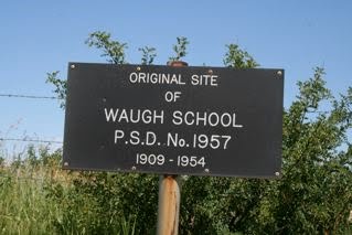
From where my wife and I sit on our front porch, 150 metres up the hill to the east is the site of the old Waugh School. 25 metres past the school site, paralleling the south to north flow of the creek, is the Athabasca Landing Trail. Edmonton is 40 miles to the south -- Athabasca 60 miles to the north. In the early days of settlement these two destinations created a huge demand for illegal alcohol (otherwise known as moonshine, screech, white lightning, hooch or various other names). Whatever name you used, it was home brew and it was illegal.
150 metres to the west of our porch runs the creek. Up the west bank another 50 metres sits an old log house. It is now part of a modern farmyard and sports a new tin roof to protect the old log walls. Back around 1908 this old house was the home of one of quickest-thinking ladies I have ever heard of.
One sunny summer day she had just finished hanging out the laundry. Behind the sheets she was busy bottling up her latest batch of home-brew. Later, these bottles would be picked up by one of the freighters heading back to Edmonton on the Athabasca Landing Trail. As she sealed the last bottle she heard the sound of hoofbeats crossing the wooden bridge on the path that led to her home. To her horror she saw that the approaching horseman was a member of the Red Serge. Within a minute he would be on her yard and her little family business would be toast.
The old wooden barrel was still full of water from the morning laundry. Without a moment's hesitation she stripped off her clothes and jumped into the barrel. When the Mountie got close she started to scream at the top of her lungs: "I am having a bath! My husband is not home! Please go away!!"
Without a word, the Mountie reined his horse around and headed back down the trail on his way to Athabasca Landing.
A month later upon returning to Ft. Saskatchewan he filled out his report: 'Naked lady in washbarrel protecting her distilling operation. Official policy to avoid compromising situations outweighed desire to investigate further. This is another case of rampant alcohol production taking place along Whiskey Creek.'
The name stuck.
Richard

What's left of the foundation from the old Waugh School overgrown with grass and wildflowers

Looking north on the Athabasca Landing Trail. Just barely visible above the sign are the remains of the Waugh brothers stopping place.

Standing on the Athabasca Landing Trail looking across the Whiskey Creek valley. The treeline through the middle is the creekbed.

Dvorski Creek wetland in the Ghost Horse Hills.

This is Whiskey Creek wetland 300 metres before emptying into Redwater River

Whiskey Creek 50 metres before entering into the Redwater River.

From the bottom of Whiskey Creek looking at the old log house with the new tin roof.
No comments:
Post a Comment